Saturday, June 24, 2006

Smoked King Salmon.

Today we purchased some smoked king salmon from a local fish monger we met. We picked it up at his house. This is typical of the residences and the coloration that one sees in this area.

Some pictures of the area


The Yukon and the Klondike Rivers join.


Friday, June 23, 2006

Sourdough Joe, Dawson City


Sourdough Joe's restaurant is located on Dawson City's first lot.
August 1896, just after the historic Bonanza creek gold strike, prospector Joe Ladue staked not a claim, but a whole town site.
Joe Ladue sold lots for only $5.00 in the winter of 1896, but by the next summer he was getting $8000.00 for them. Dawson City's population grew from 25 to 5000 in less than a year. Within 2 years, the population exploded to 40000, making it the biggest Western Canadian city.

In 1897, Joe Ladue's home was also Dawson City's first saloon. At the height of the Gold Rush, $5.00 in Dawson City got you a plate of beans and bread with stewed apples and a cup of coffee. A meal costing $2.50 in Dawson City cost only $0.15 in Seattle Washington. 8000 people left Dawson in 1899, when the Gold Rush ended. Joe went back to New York a rich man.
Prices are still a little inflated here as 2 orders with 2 pieces fish and chips with 2 coffees come to $33 and change. We do not think that just because it was Yukon King Salmon that the price was justified.

Summer Solstice Yukon


Awesome Yukon beauty surrounds us in Dawson City. We drove to a nearby mountain landmark called the "Midnight Dome" (elevation of 2964 feet). This is where Jannich went at midnight to see how summer solstice is revered in this area.


He found himself among many young people, hippies and others that were more into smoking pot and drinking. Needless to say he only stayed there till shortly after midnight. The picture with the people was taken on the Dome just after midnight and the picture of the RV park was taken at 2 AM.


The sun sets at 12:20 AM and then gets up again around 3:45 but it still does not get completely dark.

Thursday, June 22, 2006

Bonanza Gold.

Dawson City YT the major site of the Klondike Gold Rush is the city at the beginning of the "TOP OF THE WORLD HIGHWAY". The spirit of the GOLD RUSH fever is still intact.

Leaving at 7 AM this morning we drove steadily, through torturous roads, narrow with sheer drop off, with muskeg and permafrost heaves and waves. Arriving at Dawson City at 3 PM after a tiring drive of 545 km from Whitehorse on very winding roads with many hair-pin turns, we found that the RV park we chose still had Gold Rush Fever. We paid $38, (the most expensive ever) in order to stay in a hard packed gravel RV park so close to our next door neighbour we can almost touch them. Gold rush fever strikes again.


Gold Rush RV Park. Downtown Dawson City YT.
This picture was taken at 22:33 on the longest day of the year, June 21/06.

Tuesday, June 20, 2006

Robert Service, Poet!

Between 1904 and 1912 this teller for the Bank of Commerce composed volumes of verses about the Yukon. Ruth remembers being read and enjoying "The Cremation of Sam McGee" and "The Shooting of Dan McGrew" when she was in public school. Following is the first verse of nine from the SPELL OF THE YUKON


I wanted the gold, and I sought it;
I scrabbled and mucked like a slave.
Was it famine or scurvy-I fought it;
I hurled my youth into a grave.
I wanted the gold, and I got it-
Came out with a fortune last fall,-
Yet somehow life's not what I thought it,
And somehow the gold isn't all.


Below is a photo of Sam McGee's cabin. He was the subject of the composition entitled "The Cremation of Sam McGee" (fiction).

Following is the introduction to this poem.

There are strange things done in the midnight sun
By the men who moil for gold;
The Arctic trails have their secret tales.
That would make your blood run cold;
The Northern Lights have seen queer sights,
But the queerest they ever did see
Was that Night on the marge of Lake Lebarge
I cremated Sam McGee.


Whitehorse YT


Whitehorse is named after the historic rapids on the Yukon River which, to the prospectors, resembled the flowing manes of charging white horses. The White Horse Rapids became known as the greatest peril of the trail of '98. The once foaming White Horse Rapids have been tamed by a hydro Electric Dam constructed in 1958.

Yukon Beauty.


Enjoy these photos of the awesome beauty of the Yukon through which we are driving. This bridge is the longest span of the entire Alaska Highway. Its 7 sections cross Lake Teslin. This lake is 78 miles long, 2 miles wide and reaches a maximum depth of 700 feet. A Hudson Bay Company trading post was established there during the Gold Rush.

Laird River Hot Springs.


A distance North from Fort Nelson on the Alaska Highway, we stopped at the Laird River Hot Springs for a break. These springs are unique as they are not commercialized because they are in a Provincial Park. We took at 10 minute walk along the boardwalk to the river which is one continuous hot spring for more than 100 feet. Jannich enjoyed a relaxing dip.

Saturday, June 17, 2006

Watson Lake. YT


Today we drove from Watson Lake YT to Whitehorse in the YT. This was a very relaxing drive of only 385 km. The snow capped mountains against the beautiful deep blue lakes were just fantastic. We plan on staying here a few more days. I'll add more to this blog later.

Thursday, June 15, 2006

A memorial to a local youth.


This memorial is just around the corner from the NO drug dealer signs. The town of Fort Nelson has had a lot of problems lately with drugs. We were told that because this is a town with a lot of transients, many drug houses have been found here. Some people in a particular part of town have put signs on their front lawns saying NO to drug dealers. This community has a population of about 5000 people. The memorial on the picture is to a teenager killed driving an ATV. From reading all the notes from all his friends it clearly shows that this teen was into heavy duty drinking and drugs. Enlarge the picture by clicking on it and read what it is about.

RCMP MEET AND GREET IN ROADBLOCK.

June 14th Fort Nelson News carried the following informative article by the local Staff Sgt.

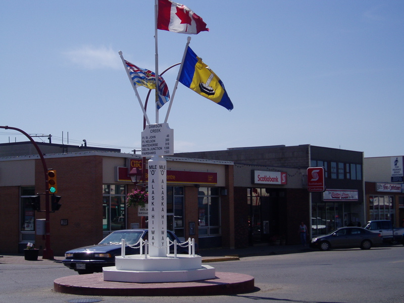
During this past weekend, members of Fort Nelson Traffic Services and the Conservation Service took advantage of the lovely weather and sunshine to meet and greet people during a road safety check at Mile 307 along the Alaska Highway.

During this road safety check, RCMP members met several drivers who apparently did not realize that you cannot operate a motor vehicle while intoxicated, you cannot enjoy a cool "alcoholic beverage" while driving (no matter how warm the weather is or how good you feel), you should never carry illegal drugs in your vehicle, you definitely require a drivers license to operate motor vehicle and you should always wear your seat belt, especially if you're going to speed up to a police check.

RCMP really frown on this type of driving behaviour which usually spoils the driver's day too. Especially when they have to walk home with a handful of traffic tickets and try to explain to a curious parent or spouse where their vehicle is.
Below is a list of some of the other things the RCMP and Conservation Service members found during their day in the sunshine:
5 Impaired drivers
5 Unlawful possessions of alcohol in a vehicle.
2 Possessions of drugs.
1 Prohibited driver.
1 Vehicle impound.
1 Unlawful possession of a firearm.
1 Weapon.
24 Failures to wear seat belts.
10 Speeding.
2 Driver without a license.
5 Illegal wild life.
2 Vehicles drivers taken out of service.
3 Log book pre-trip inspections.
6 Other driving infractions.
The remainder of the article was taken from statistics of safe driving in British Columbia.

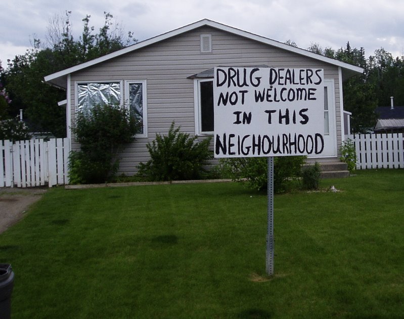
You cannot make this stuff up. This seems to be an area that is lacking recreational facilities. As we drove around the streets in the town today we noted rampant poverty, unkempt establishments and properties with signs on the lawn warning drug dealers to stay out. Perhaps this is one of the last frontiers of Canadian Missionary work. It is within driving distance and you do not need a passport. The only church we saw here was the Jehovah Witness Church.


Fort Nelson news.

Tuesday, June 13, 2006

Dawson Creek BC. Mile Zero on Alaska Highway


In 1941, the Japanese attacked Pearl Harbour Hawaii. This event forced the American and Canadian governments to re-evaluate their security.

Dawson Creek is located at Mile Zero on the Alaska Highway. Its population exploded in 1942 when U.S. troops led American and Canadian civilians in a rush to construct a 2400 km/1491 mile military supply route to Alaska. Pushing the trail through was accomplished in an amazing 8 months and 12 days. Building this road through this vast untamed wilderness of Northern Canada and Alaska was not an easy feat. The workers had to battle the mountains, muskeg and mosquitoes. Frostbite, extreme cold and heatstroke were other factors.
In March 1942, Dawson Creek, a small Northern Canadian community with the population of 600 people bustled and swelled with activity when the first trains filled with American troops arrived. In a matter of weeks the town's population exploded to 10,000. On November 20, 1942, mile 1061 (known as soldiers' summit) saw the ribbon cutting ceremony that officially opened the "Alcan" Highway. The 1528 mile road included 133 major bridges and more than 3000 culverts. The cost of this construction was approximately 140 million U.S. wartime dollars. After the war, this wilderness highway captured the imagination of urban pioneers everywhere and the Great Alaska Highway legend gathered momentum. On September 28 1996 in a ceremony held at Dawson Creek the Alaska Highway was designated as the 16th International Historic Civil Engineering Landmark.


Boomtown 2006


Edmonton, Alberta: prosperous, clean, upbeat, on a high, with continuous home and road construction. These are just a few of the ways to begin to describe this city.
With oil money fueling this prosperity Edmonton shows evidence of outstanding urban planning. From the parks, the green spaces with lakes, controlled diversified home building to the unique malls and shops that resemble houses this area is emerging as a leading Canadian city. Apparently it is the fastest growing city in Canada at this time.

If we were 20 years younger we would pack up and move here as there are employment opportunities available in all sectors. We were told that servers in Tim Hortons coffee shop in Fort McMurray are paid $20 per hour. The Alberta tar sands are in the vicinity of Fort McMurray.


Having spent the past 2 weeks in the Whitemud Creek RV park we discovered after 3 days of steady rain why it is called white mud. The range roads dividing off the sections are not gravelled and many are not paved. After a short trip on these roads our truck was covered over the cab with "white mud". It dries hard and is very difficult to remove. This gives one some compassion for the settlers of the 1800s. During our 2 weeks here we visited with Ruth's nephew Darwin and his family and explored Edmonton and the surrounding area. On Monday June 12 we are preparing to travel to Dawson Creek BC.

Sunday, June 04, 2006

Yellowhead Highway Corridor.

It is the modern highway whose history is the song and legend of the voyageurs, the adventurous fur trade, the dreams of settlers and the fevered pitch of the Gold Rush.
It was the secret trail to the fur cache of the golden-locked Iroquois Metis guide known as "Tete Jaune". Tete Jaune, (literally translated as Yellowhead) was the nickname for the Iroquois Metis who guided for both of Canada's greatest business rivals, the North West Company and the Hudson's Bay Company, the dominant fur traders of the world. His blazed path proved to be an easier route from Manitoba to British Columbia so that by the 1830s, the Yellowhead Trail was virtually a highway.
Red River carts rumbled along it in 1841, miners walked its length for the Caribou Gold Rush in 1856 and eager settlers followed it to file on their new homesteads in the West. The Trans-Canada Highway Association was formed in 1947 and drove the four Western Provincial Governments to build the Yellowhead Highway Corridor. The Yellowhead Highway was opened in 1970. We have enjoyed traveling this scenic route from Winnipeg to Edmonton but must leave it now to travel North to Dawson Creek, British Columbia.

Friday, June 02, 2006

Saskatoon, Saskatchewan.


During our 3 night stay at Saskatoon we visited the Western Development Museum Boomtown Years 1910. An older man started walking with us and started telling about his early years in this area. We found out that SANDY is 86 and has been volunteering at the museum 2 days a week as a living "MEMORY BANK" since 1978! He told us that the name Peter/Peters (Ruth's maiden name) was common during that period of time as Saskatchewan was being developed. Settlement was rapid in the late 1890's and early 1900's. Agricultural development gained strength after farmers began to plant a type of wheat that thrived in Saskatchewan's short growing season.


New settlers established homesteads in record numbers. From 1901 to 1911, the population increased from 91,279 to 492,432. Good free land and rising wheat prices attracted many immigrants from Scandinavia and Central and Eastern Europe. Rapid population growth spurred the building of railroads, towns, and cities.
Saskatchewan became a province of Canada in 1905. But the federal government kept control of Saskatchewan's public lands and natural resources, including its forests and mineral deposits, until 1930.

Petroleum is Saskatchewan's most important mined product. The province has four major petroleum-producing regions: Estevan-Weyburn in the southeast; Swift Current and Kindersley, both in the southwest; and Lloydminster in the west-central part of Saskatchewan. About 60 percent of the petroleum mined in Saskatchewan is exported to the United States. Much of the remainder of Saskatchewan's production is sold in Canada's eastern provinces.

Saskatchewan is North America's leading producer of potash. Saskatchewan's potash mines are located in the southern third of the province.

We finished our visit with a coffee at the authentic Boomtown Cafe

After buying some Saskatoon Berry pie and some perogies we left for Alberta. Vast sections of Saskatchewan were pioneered by Ukrainians and Russians.